


Colorado’s prime fourteener season is still at least a few weeks away — snow clings to much of the high country — but controversy already simmers.
For all of May, the popular trip known as DeCaLiBron is off-limits. Citing liability concerns, the landowner closed property on mounts Lincoln and Democrat, two along the trail covering the cluster of 14,000-foot peaks outside Alma.
Advocates in contact with the landowner expect the closure to lift come June. That includes Lloyd Athearn, executive director of Colorado Fourteeners Initiative.
“Hopefully this catches people’s attention,” he said.
It’s just the latest example of consequences due to the increasing abuse of private land and the broader environment surrounding the state’s tallest mountains.
For Quandary Peak near Breckenridge, an ongoing survey is exploring the possibility of permits and shuttles.
And concern continues at the base of Grays and Torreys peaks, two other highly trafficked fourteeners in Clear Creek County, where parking along a narrow access road threatens to block emergency vehicles and widespread camping frustrates property owners.
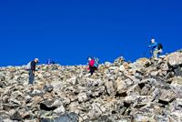
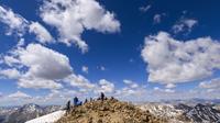
Bigger crowds bring more off-trail trampling, more damage to the tundra, and more trash and unattended excrement — both dog and human.
“Education is just a constant thing we have to do,” Athearn said.
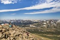
That’s while numbers show no signs of letting up. From in-ground trail counters the past few years, Fourteeners Initiative has estimated more than 35,000 hikers on Quandary every summer, with Democrat, Lincoln, Grays and Torreys seeing upward of 25,000.
Preliminary data suggest those numbers surged 20% in 2020, Athearn said.
For anyone looking to join the fourteener craze in 2021: “Understand that these are extremely high mountains, and even doing some of the quote-unquote easiest fourteeners involves a lot of physical ability,” Athearn said. “The other part is really doing your homework.”
Along with DeCaLiBron, Quandary, Grays and Torreys, here’s a look at other “beginner” peaks to consider:
Mount Bierstadt (14,060 feet)
Stats: 7 miles round trip, 2,850 feet elevation gain (West Slopes route)
Getting there: Off Interstate 70, exit for Georgetown and follow Guanella Pass about 12 miles to the trailhead.
Description: Considered to be among the simplest routes in all of fourteenerdom. It’s a gentle start through willows and creek crossings before steeper stretches on Bierstadt’s broad shoulders. The trail stays clear until about the last quarter-mile. You’ll have to manage some boulders for the summit.
Mount Elbert (14,433 feet)
Stats: 9.5 miles round trip, 4,700 feet elevation gain (Northeast Ridge)
Getting there: From U.S. 24 south of Leadville, turn onto Colorado 300. In less than a mile, turn left for County Road 11. Continue 1 mile and turn right toward Halfmoon Creek. Drive 5 miles to trailhead.
Description: Conveniently, a well-defined path leads to Colorado’s highest heights. But don’t dare take this venture lightly. Where six hours is a fair time estimate for other hikes on this list, Elbert might demand closer to nine.
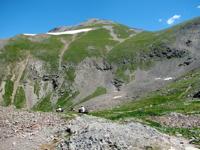
Handies Peak (14,048 feet)
Stats: 8 miles round trip, 3,650 feet elevation gain (Silver Creek/Grizzly Gulch trailhead)
Getting there: From Lake City, drive about 2 miles south on Colorado 149, turning right onto County Road 30. Reach the trailhead in 16 miles on the dirt road.
Description: If you’re wanting a taste of 14,000 feet in the legendary San Juans, this might be the way to do it. Fans are familiar with the four-wheel drive approach from American Basin, but Grizzly Gulch is friendlier; the road in, when dry, accommodates passenger cars, though some clearance is recommended. Gerry Roach calls the route “classic” in his guidebook “Colorado’s Fourteeners.” He considers it Class 1+, with some exposed pitches and loose rock.
Huron Peak (14,003 feet)
Stats: 6.5-10.75 miles round trip (depending on where you park), 3,500-3,800 feet elevation gain (Northwest Slopes)
Getting there: From Buena Vista, go 14.5 miles north on U.S. 24 and turn left onto County Road 390. The dirt road (fine for passenger cars) runs about 12 miles to the Winfield ghost town. Either park ahead or, if you have four-wheel drive, continue up the rough road 2 miles to the trailhead.
Description: It barely cracks 14,000 feet — “but compensates by being the Sawatch fourteener that is farthest from a paved road,” Roach writes. “The view,” he adds, “is one of the best.” While his book classifies the route as Class 1, 14ers.com catalogs it as Class 2, with “moderate” exposure and rockfall potential.
Source: 14ers.com


 Your Privacy Choices